
M12 Observation Details

M12 Daily Motion
M12 will be visible until October, 16, when it will move too close to the Sun. During this time, its proximity to the Sun will cause it to disappear from the night sky, making it unobservable for a while.
M12 Visibility Timetable on May 11
M12 Rise and Set Timetable
| Time | Elevation | |
| Moon Rise, 97.2% illuminated | 19:00 | -24° |
| M12 rise | 21:09 | |
| Astrosession begin | 22:24 | 14° |
| M12 transit | 03:01 | 48° |
| Astrosession end | 04:32 | 43° |
| Moon Set | 05:28 | 36° |
| Civil sunrise | 05:50 | 33° |
| Sunrise | 06:21 | 28° |
| M12 set | 08:54 |
Track M12 Position Throughout the Night
← Sun, 11 May 2025 →
| Time | |
| Altitude | |
| Azimuth |
M12 - Globular Cluster
M12 is a globular cluster located in the constellation Ophiuchus. It was discovered by Charles Messier in 1764. This cluster is less concentrated than other globular clusters in Messier's catalog.
M12 spans about 75 light-years across and contains tens of thousands of stars. The cluster is approximately 15,700 light-years away from Earth and has an apparent magnitude of 6.7, making it visible with binoculars or a small telescope.
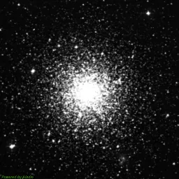
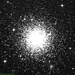
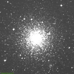
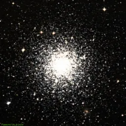
M12 Image Gallery
DSS Blue
DSS Red
DSS Near-Infrared
DSS Composite image
The photos are taken from the Digitized Sky Survey 2 (DSS2), which was produced at the Space Telescope Science Institute (STScI) under NASA contract, using data from the UK Science and Technology Facilities Council (STFC), the European Southern Observatory (ESO), and the National Geographic Society-Palomar Observatory Sky Survey (POSS II).
Special thanks to the National Optical Astronomy Observatory (NOAO), the Royal Observatory, Edinburgh, and the California Institute of Technology for their significant contributions.
Finder Chart for M12
| Object name | M12 |
| Field of view | |
| Limiting magnitude | |
| M12 coordinates | 16.78737, -1.94783 |
| Center coordinates | 16.78737, -1.94783 |
M12 Passage Through Night
Current position of M12
| Time | 02:23 |
| Latitude | 39.9625 |
| Longitude | -83.0061 |
| M12 elevation | 47° |
| M12 Azimuth | -166° |
Annual motion of M12
| Date | Mon, 12 May 2025 |
| Twighlight start | 22:21 |
| Twighlight end | 04:25 |
| Twighlight duration | 6h 4m |
| Rise | 21:05 |
| Set | 08:50 |
| Elevation at transit | 48° |
| Transit time | 02:58 |
| Equatorial coordinates | RA: 16h 47m 14s", Dec: -1° 56' 52s |
| Magnitude | 6 |
| Constellation | Ophiuchus |
The graph is structured with the vertical axis showing the hours of the day, ranging from 12 AM to 12 AM the next day, while the horizontal axis spans each day of the year.
The reddish shaded area indicates the periods when the M12 is above the horizon, visible to observers. The white line marks the times when the celestial object reaches its highest point in the sky each day, known as the transit.
Data Credits
The nebulae information on this page is sourced from the OpenNGC project, developed by Matteo Verga. OpenNGC provides detailed data on the NGC catalog, which is a valuable resource for exploring deep-sky objects such as nebulae.
For more details or to contribute to OpenNGC, visit the official GitHub repository: OpenNGC on GitHub.