
Near Real-Time Satellite Imagery for Sky Conditions
Welcome to our Near Real-Time Satellite Imagery resource, designed for astronomers and stargazers who need up-to-date information on cloud cover. Our satellite imagery, updated frequently but displaying images from the last hour, is sourced from NOAA, EUMETSAT, and Himawari satellites, providing a near real-time view of cloud conditions globally. This tool allows you to plan your observations with confidence by monitoring cloud cover, especially over your specific region.
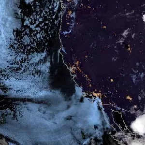
Cloud Cover Conditions Over Your Region
| ⏸ |
Why Use Near Real-Time Satellite Imagery for Sky Conditions?
We gather data from leading satellite sources, offering extensive coverage across key observational regions:
- NOAA (National Oceanic and Atmospheric Administration): Covering the Americas, NOAA provides detailed cloud tracking, assisting with planning observations across the western hemisphere.
- EUMETSAT (European Organisation for the Exploitation of Meteorological Satellites): Focused on Europe, Africa, and parts of the Indian Ocean, EUMETSAT delivers current cloud cover information in these areas, supporting astronomers in those regions.
- Himawari: Covering the Asia-Pacific region, Himawari offers high-resolution data for countries like Japan and Australia, providing continuous updates for stargazers in the eastern hemisphere.
By default, the last 3 images, covering the fourty minutes, are shown. However, you can check images for the last 24 hours using the slider, allowing you to view cloud cover changes over time.
With our platform, you can access satellite images that are only about an hour old, enabling you to:
- Check cloud cover before setting up equipment.
- Evaluate sky conditions across regions.
- Plan your observations with confidence, ensuring clear skies for optimal visibility.
This near real-time imagery offers cloud cover data crucial for informed stargazing, ensuring a more productive and enjoyable experience.
Credits
This service relies on satellite data provided by NOAA (GOES), EUMETSAT (Meteosat), and Himawari. We extend our thanks to these organizations for their commitment to providing high-quality, real-time satellite imagery that supports astronomers and sky enthusiasts worldwide.