
M29 Position and Visibility Tonight
Where is M29 right now?
Twilight begins at 19:25 local time, and at that moment, M29 will appear at an altitude of 46 degrees toward the northeast.
M29 Visibility on July 27
M29 Rise and Set Timetable
| Time | Elevation | |
| M29 rise | 14:43 | |
Moon Rise, 93.7% illuminated  | 16:49 | 18° |
| Sunset | 18:19 | 34° |
| Civil sunset | 18:50 | 39° |
| Twighlight start | 19:25 | 46° |
| Astrosession begin | 20:04 | 53° |
| M29 transit | 23:11 | 89° |
| Moon Set | 02:03 | 56° |
| Astrosession end | 02:24 | 52° |
| Twighlight end | 03:03 | 45° |
| Civil sunrise | 03:39 | 38° |
| Sunrise | 04:09 | 33° |
| M29 set | 07:39 |
Track M29 Position Throughout the Night
← Mon, 27 July 2026 →
| Time | |
| Altitude | |
| Azimuth |
M29 - Cooling Tower Cluster
M29 is an open cluster located in the constellation Cygnus. It was discovered by Charles Messier in 1764. The cluster contains a relatively small number of stars compared to other open clusters in Messier's catalog.
M29 spans about 11 light-years across and contains around 50 stars. The cluster is approximately 4,000 light-years away from Earth and has an apparent magnitude of 7.1, making it visible with binoculars or a small telescope.
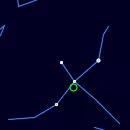
Finder Chart for M29
| Object name | M29 |
| Field of view | |
| Limiting magnitude | |
| M29 coordinates | 20.39938, 38.50767 |
| Center coordinates | 20.39938, 38.50767 |
M29 Passage Through Night
Current position of M29
| Time | 07:43 |
| Latitude | 37.3541 |
| Longitude | -121.955 |
| M29 elevation | 0° |
| M29 Azimuth | 322° |
Annual motion of M29
M29 will be visible until January, 15, when it will move too close to the Sun. During this time, its proximity to the Sun will cause it to disappear from the night sky, making it unobservable for a while.
| Date | Mon, 27 July 2026 |
| Twighlight start | 20:00 |
| Twighlight end | 02:17 |
| Twighlight duration | 6h 17m |
| Rise | 14:43 |
| Set | 07:39 |
| Elevation at transit | 89° |
| Transit time | 23:11 |
| Equatorial coordinates | RA: 20h 23m 57s", Dec: 38° 30' 27s |
| Magnitude | 7 |
| Constellation | Cygnus |
The graph is structured with the vertical axis showing the hours of the day, ranging from 12 AM to 12 AM the next day, while the horizontal axis spans each day of the year.
The reddish shaded area indicates the periods when the M29 is above the horizon, visible to observers. The white line marks the times when the celestial object reaches its highest point in the sky each day, known as the transit.
You can also view detailed visibility information in a dedicated table, including exact rise, transit, and set times for each date.
Astrometric & Physical Parameters of M29
Coordinates & Visibility
| Right Ascension | 20.39938° |
| Declination | 38.50767° |
| Magnitude | 6.60 |
| Constellation | Cygnus |
| Elevation | 0° |
| Azimuth | 321.6° |
Data Credits
The nebulae information on this page is sourced from the OpenNGC project, developed by Matteo Verga. OpenNGC provides detailed data on the NGC catalog, which is a valuable resource for exploring deep-sky objects such as nebulae.
For more details or to contribute to OpenNGC, visit the official GitHub repository: OpenNGC on GitHub.