Sky Tonight
ST
Location settings
Singapore, SG 1.4°/103.8°
GMT +8
Waning19:36 - 06:00
⌕
Go to My SkyLog in
☾
☰
  • 🌐 EN
    ENDEESFRPT中文
  • Tonight
    • Brightest Planets and Stars Tonight
    • Milky Way Tonight
  • Solar System
    • Sun
    • Real-Time Sun Map
    • Sunspots Activity
    • Aurora Activity
    • Moon
    • Interactive Lunar Map
    • Planets
    • Mercury
    • Venus
    • Mars
    • Jupiter
    • Saturn
    • Satellite Flyovers
    • ISS
    • Close Approaches
  • Small Bodies
    • Asteroids
    • Comets
    • Recently Updated Comets
  • Stars
    • Brightest Stars
  • Meteor Showers
    • Active Meteor Showers
    • Major Meteor Showers
  • Solar Eclipses
    • Future Solar Eclipses
    • Past Solar Eclipses
  • Lunar Eclipses
    • Future Lunar Eclipses
    • Past Lunar Eclipses
  • Deep Sky Objects
    • Seasonal Nebulae
    • Messier Objects
    • Nebulae
    • Star Clusters
    • Galaxies
  • Double Stars
    • Naked-eye
    • Binocular
    • Physical pairs
    • Color-contrasting
    • Triple systems
    • Multiple systems
  • Constellations
    • Visible Tonight
    • Seasonal
    • Ecliptic
    • All 88 Constellations
  • Maps
    • Printable Astronomy Maps & Star Charts
    • Mars Map
    • Mercury Map
    • Earth
    • Cloud Cover Map
  • Contact Us
    • Feedback

Observation Settings

Or select it on the map:
This Earth map lets you select the observer’s location used to calculate the bearing and elevation of celestial objects. The selected point determines how the sky, rise and set times, and object positions are shown.
Your location: Singapore, Singapore
Timezone:
Latitude:
1.35208
Longitude:
103.82

Printable Star Charts

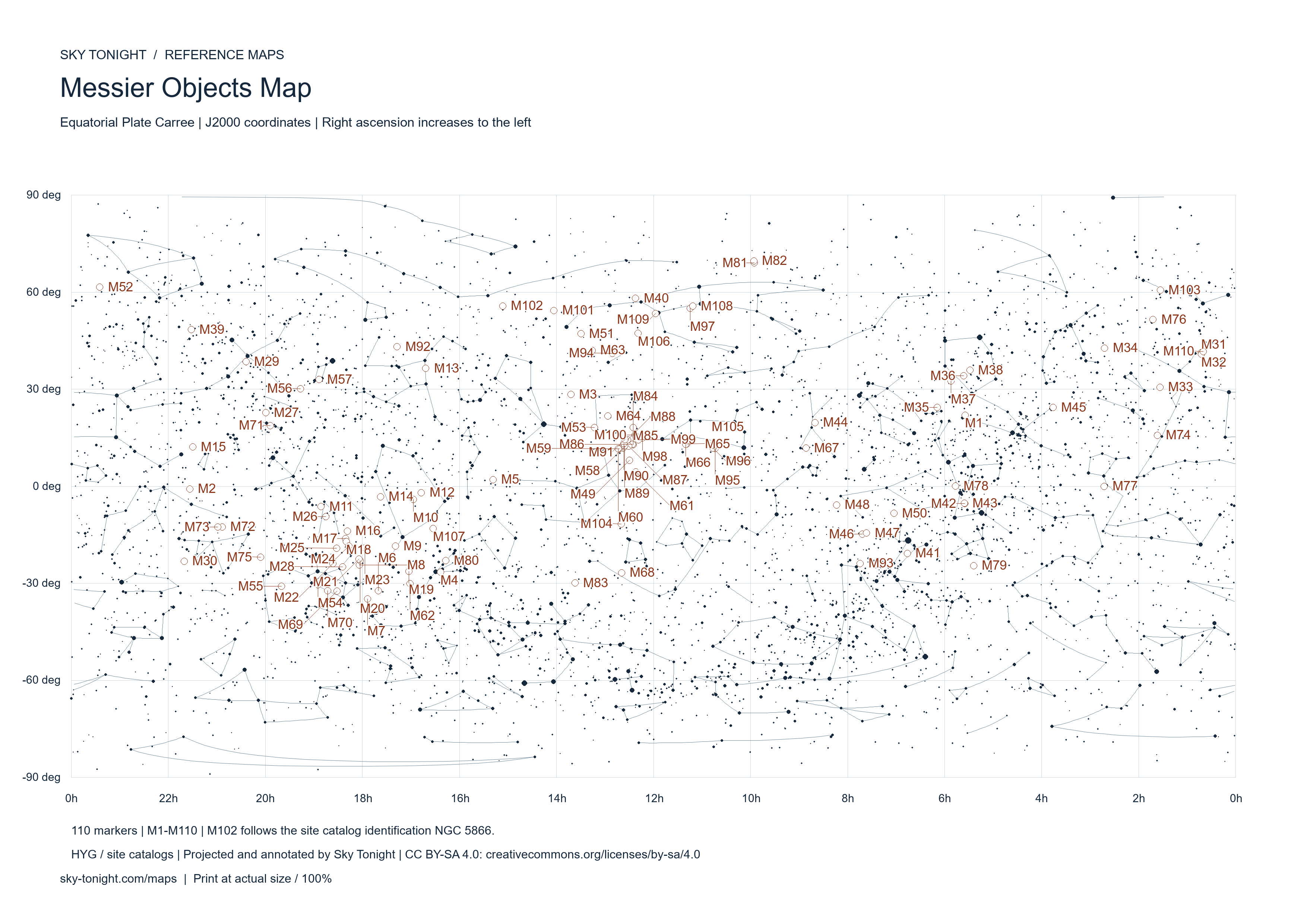
Static J2000 star charts with constellation figures and a map of all 110 Messier objects. Choose names, a light or dark background, A4 or A3, then download PDF or 300 DPI PNG.

All mapsPrintable Star ChartsHigh-Resolution Moon Maps with NamesPrintable Mars MapsSky for Your Location
Northern Hemisphere Star ChartSouthern Hemisphere Star ChartMessier Objects Map

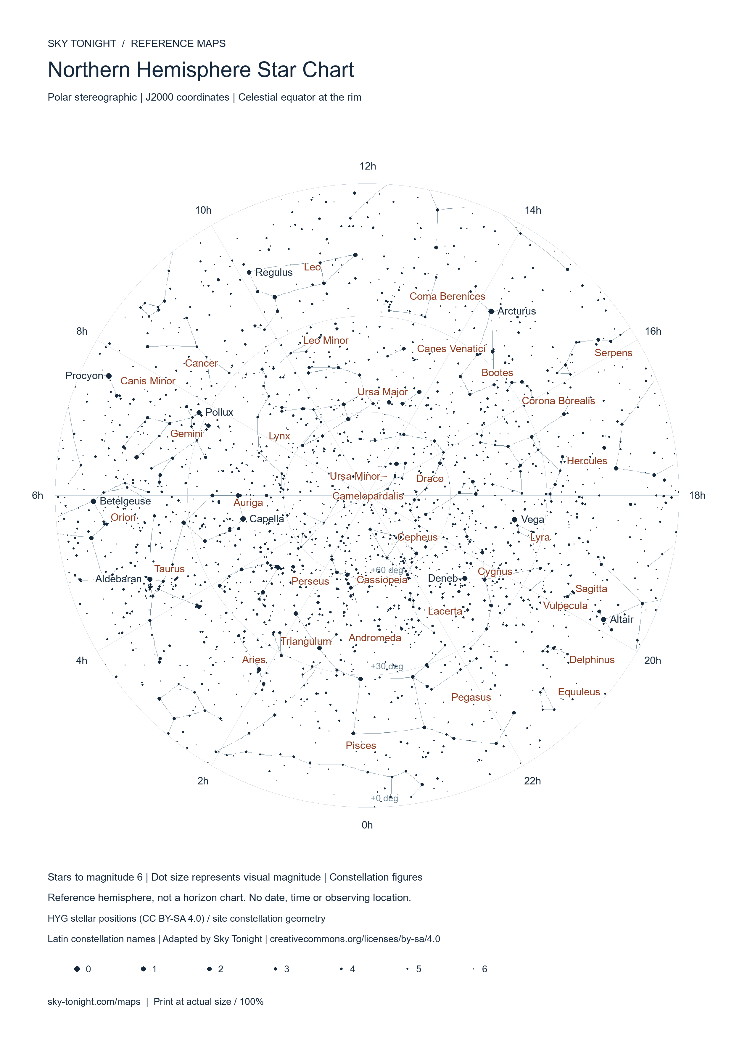
Northern Hemisphere Star Chart

Printable polar stereographic chart of the northern celestial hemisphere, with stars to magnitude 6 and major constellation figures.
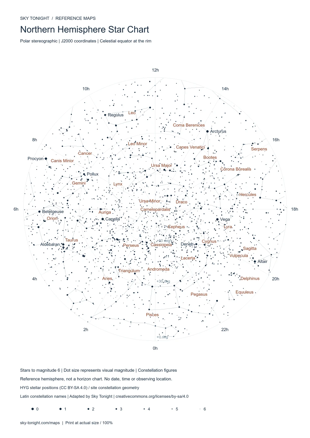
Northern Hemisphere Star Chart. Printable polar stereographic chart of the northern celestial hemisphere, with stars to magnitude 6 and major constellation figures.
Reference map. Surface names and constellation names use international nomenclature.

With names · Light · A4 · PDF

Download mapPrint map

Download PNG

Print the downloaded file at 100% size. PNG files use 300 DPI; star-chart PDFs retain vector stars, lines and text. A4 and A3 include print margins.

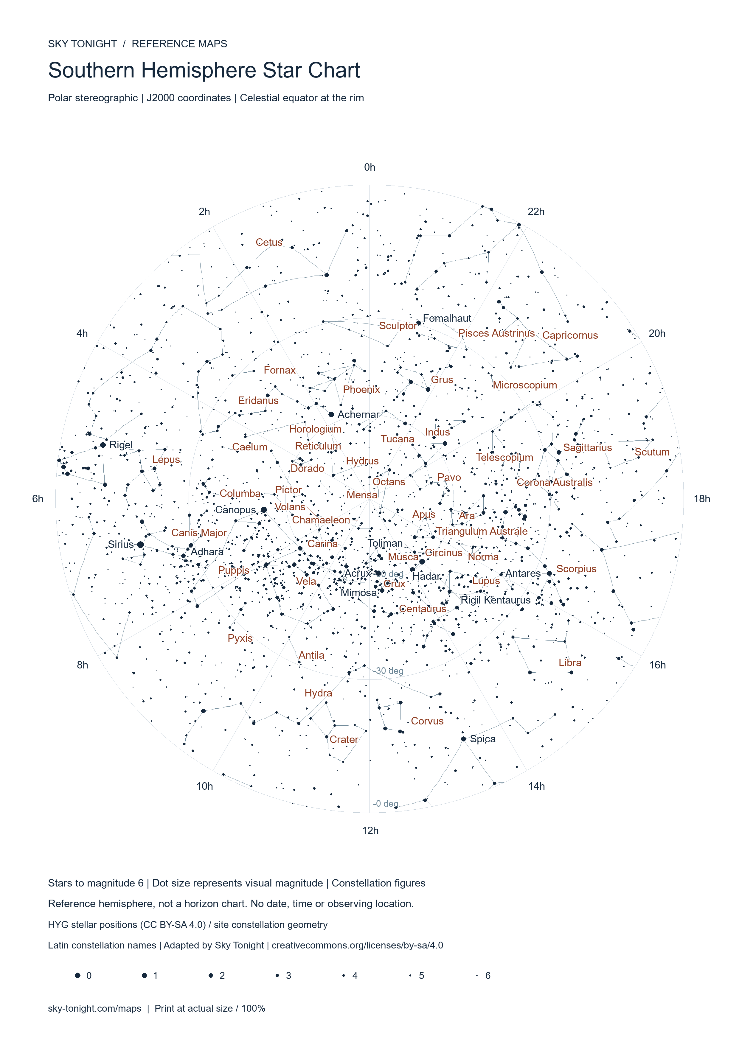
Southern Hemisphere Star Chart

Printable polar stereographic chart of the southern celestial hemisphere, with stars to magnitude 6 and major constellation figures.
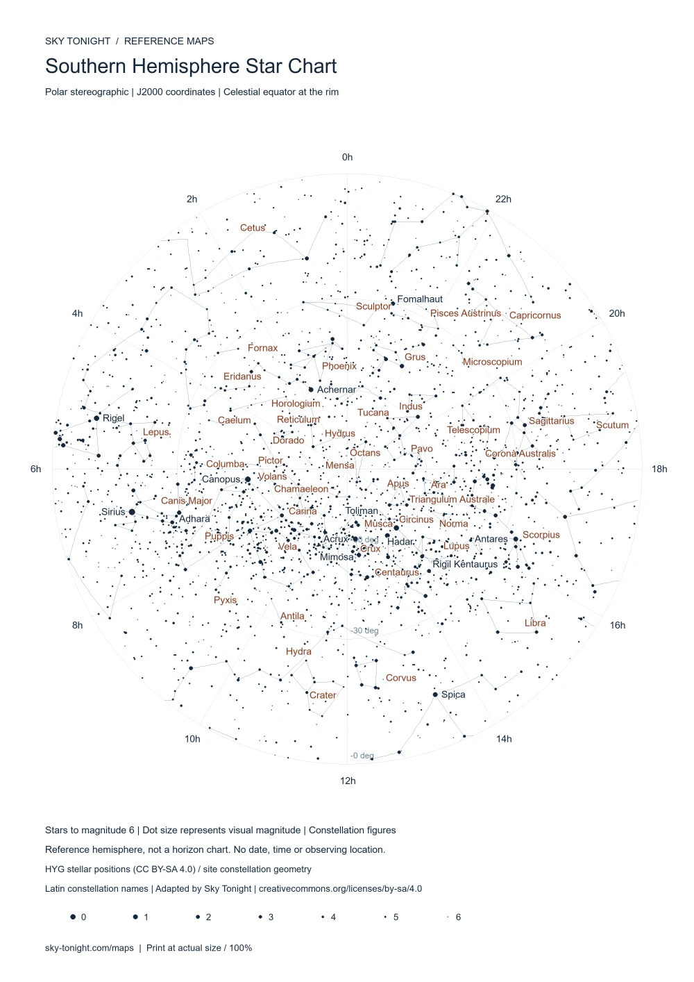
Southern Hemisphere Star Chart. Printable polar stereographic chart of the southern celestial hemisphere, with stars to magnitude 6 and major constellation figures.
Reference map. Surface names and constellation names use international nomenclature.

With names · Light · A4 · PDF

Download mapPrint map

Download PNG

Print the downloaded file at 100% size. PNG files use 300 DPI; star-chart PDFs retain vector stars, lines and text. A4 and A3 include print margins.

Messier Objects Map

All 110 Messier objects on an equatorial reference chart, with M1–M110 identifiers, star positions and constellation figures.
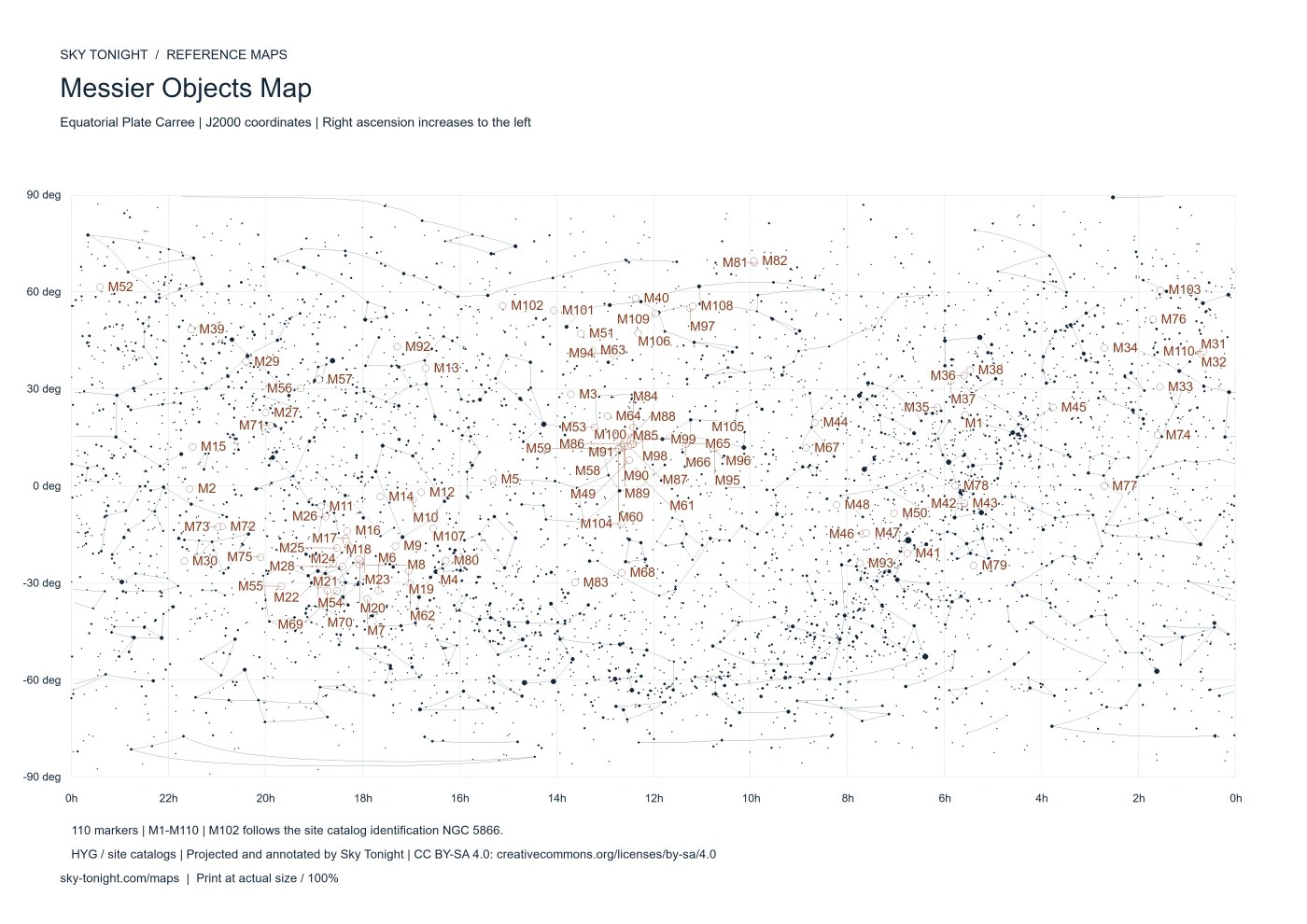
Messier Objects Map. All 110 Messier objects on an equatorial reference chart, with M1–M110 identifiers, star positions and constellation figures.
Reference map. Surface names and constellation names use international nomenclature.

With names · Light · A4 · PDF

Download mapPrint map

Download PNG

Print the downloaded file at 100% size. PNG files use 300 DPI; star-chart PDFs retain vector stars, lines and text. A4 and A3 include print margins.

Explore the interactive map

Data sources and print quality

Moon: NASA’s 2025 display mosaic, with lower-resolution polar albedo fill; not quantitative photometry. The native 2600 px disk prints at 180 mm (A4) or 220 mm (A3). Mars: 8192 × 4096 NASA Trek Viking mosaic. Map sheets use English headings, international Latin constellation names and IAU surface names, shared across languages. Stellar charts use J2000 positions; they do not show the local horizon. M102 follows the site catalog identification NGC 5866.
  • NASA SVS / LROC / LOLA — CGI Moon Kit · 8192 × 4096
  • NASA / JPL / USGS / Ames — Viking MDIM 2.1 · 8192 × 4096
  • IAU / USGS Gazetteer of Planetary Nomenclature
  • HYG Database · CC BY-SA 4.0